As Sandy leaves South Florida and aims for the Northeast, at least 42 are dead in its wake in Cuba, Haiti and Jamaica.
Mud gushed down from mountains, boulders barreled into highways and bedraggled residents waded through chest-deep flooding to get to homes under water, www.miamiherald.com reports.
As Hurricane Sandy drenched Haiti for a fourth day, a weary country wondered when the rain would finally end. "We weren't prepared. No one was prepared," said Rose-Marie Lapotose, 40, walking through rain in a town stunned by the deaths of a mother and four children, buried under an overnight mud slide that crushed their home.
Sandy edged away from Florida on Friday toward a paralyzing smash into the Northeast that experts fear could dwarf the $15 billion-plus in damages racked up by Hurricane Irene last year. But another disaster was still unfolding hundreds of miles south in Haiti, where Sandy's long wet tail has draped itself over Hispaniola and might not move until the weekend.
Haiti's Office of Civil Protection raised the death toll to 29 late Friday, a number that could climb in a poor country vulnerable to mudslides. That brought the number of deaths in the Caribbean to at least 42, including 11 in Cuba, one in Jamaica and one in the Bahamas.
But as other countries began to clean up, rain-socked Haiti was dealing with spiraling problems. Cholera cases were spreading, nearly 18,000 people were in shelters, at least four were missing and damage reports were still coming in.
"The situation is disastrous all over the country," said Prime Minister Laurent Lamothe, who issued an appeal for help and supplies, everything from flashlights to energy bars. "We are doing our best, but we need help to deal with this."
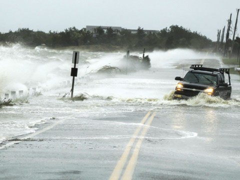
At 11 p.m., Sandy remains a hurricane as it moves slowly northward away from the Bahamas with maximum sustained winds of 75 mph, according to the National Hurricane Center. The storm continued to degrade, just hanging on to it's Category 1 hurricane status. But forecasters cautioned the slight weakening won't make a difference if Sandy behaves as expected, hooking up in a few days with an approaching cold front and morphing into a hybrid storm meteorologists have dubbed "Frankenstorm.''
During a conference call, experts with the National Oceanic and Atmospheric Administration said Sandy could produce unprecedented impacts across hundreds of miles from the Carolinas to New England. "We are dealing with categories here that we don't normally see," said Louis Uccellini, NOAA's environmental prediction director.
The forecast was dismal: 10 inches of rain near landfall, up to 8 inches elsewhere, along with coastal flooding from storm surge that could coincide with extreme high tides. West Virginia and bordering areas could see a foot of snow. Winds could top 50 mph.
James Franklin, chief of the NHC's forecast division, said the slow-moving storm could spend two or three days over the Northeast, which would multiply flooding, power outages and damage. "We're looking at something bigger than Irene," he said.
In South Florida, the weather began clearing by afternoon and the NHC dropped tropical storm watches. Emergency managers reported few problems, other than scattered power outages. Water managers reported no serious flooding from persistent but mostly light rains.
In Fort Lauderdale, storm surge left a section of A1A near Sunrise Boulevard in a calf-deep sluice of sea water and sand. Chuck Lanza, Broward County's emergency director, said crews were clearing the road.